|
Disused Railways |
|
|
||
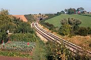 |
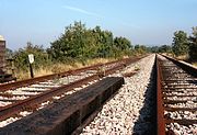
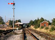
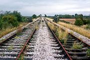
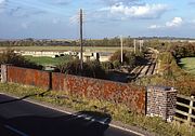
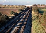
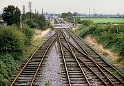
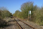
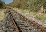
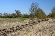
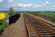
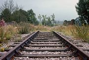
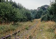
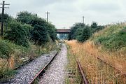
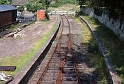
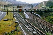
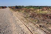
The disused Cheltenham to Stratford-upon-Avon line at Hunting Butts, on the northern edge of Cheltenham, pictured on 7 October 1978. At this time the line had been closed for two years, but track lifting had yet to start. This is the view from the Prestbury to Swindon village road, with Hunting Butts Tunnel in the distance, and Hunting Butts, the farm which gives its name to the tunnel clearly visible on the hillside on the right. The farm is pretty much the only constant in this picture, as virtually everything else has now changed. The track has gone, the tunnel is blocked, and even the well tended vegetable garden in the foreground has disappeared. |
|
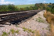 |
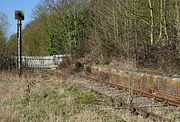
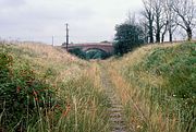
The Cheltenham to Stratford-upon-Avon railway was closed as a through route in 1976, and has subsequently been partially reopened by the Gloucestershire Warwickshire Railway, starting from their base at Toddington. Unfortunately the society was formed after the track had been lifted and consequently many hours of manpower have gone into reinstating the track in various stages. One section that is unlikely to be reinstated is the portion between Cheltenham and Cheltenham Racecourse. A severe ballast washout is pictured here just to the south of Hunting Butts Tunnel on 14 October 1979. |
|
 |
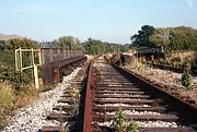
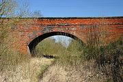
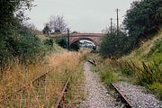
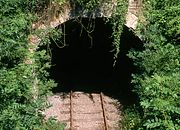
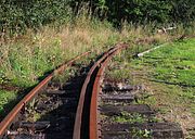
The south portal of Hunting Butts Tunnel, on the disused Cheltenham to Stratford-upon-Avon route is pictured on 14 October 1979, just a few weeks before the track was lifted. The extremley rusty condition of the rails indicates that no train has passed this spot for over three years. After track lifting the tunnel acquired the inevitable steel fence barring all access. |
|
 |
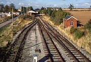
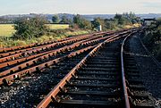
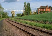
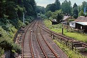
Two years after the line closed as a through route, the Cheltenham to Stratford-upon-Avon line is pictured at Gotherington on 7 October 1978. When I revisited this spot almost exactly a year later the track had just been lifted. Now, of course, the Gloucestershire Warwickshire Railway have reinstated this section of line. Just out of sight around the corner is the Dixton road overbridge, while a short distance behind where I am standing is the now reopened Gotherington Halt. |
|
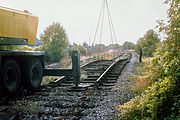 |
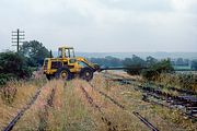
Although the Gloucestershire Warwickshire Railway Society was formed in 1976, by the time they were in a position to actually save the line, the track had unfortunately been lifted. I have included this picture, despite its poor technical quality (looking straight into the light on a misty morning), as I have seen very few pictures of track lifting on what is now the Gloucestershire Warwickshire Railway. The date is 14 October 1979, and guided by a single workman (in typical pre health & safety low-vis black clothing!), another track panel is wrenched from the ballast near Gotherington. |
|
 |
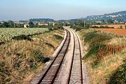
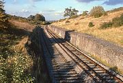
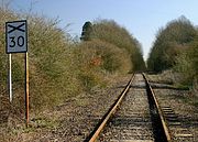
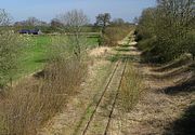
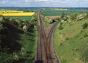
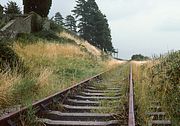
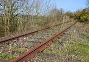
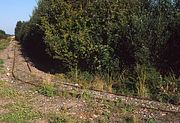
The disused Cheltenham to Stratford-upon-Avon route is pictured here near Prescott on 7 October 1978, looking towards Winchcombe. The line had closed two years previously, but the track was left in situ until 1979. This section of line has now been reinstated by the Gloucestershire Warwickshire Railway, albeit with only a single track. |
|
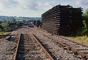 |
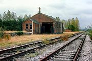
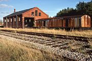
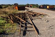
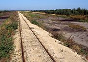
The end of the line at Winchcombe on 14 October 1979. Huge piles of reclaimed track sections dominate this view, as track lifting operations are under way to dismantle the former Cheltenham to Stratford-upon-Avon route, which closed three years previously. Although the flat bottom rail sections are being saved complete, the bullhead rail sections were being removed piecemeal, with a crane lifting out the rails and the sleepers then being dug out of the ballast individually. Note that the keys have already been knocked out of the chairs of the line on the right in the foreground. Winchcombe Goods Shed (now the Gloucestershire Warwickshire Railway's carriage department) can be seen in the background, with the demolition contractor's vehicles just in front. |
|
 |
A familiar location for present day railway photographers, but long before it became one of the most well known vantage points on the Gloucestershire Warwickshire Railway. This is Hailes, pictured on 7 October 1978. As can be seen from the rusty track, there would be no point waiting for a train to appear, as the last one passed this way a couple of years previously! The GWR had opened Hayles Abbey Halt (note the different spelling) at this spot in 1928, but that had closed, along with all the other stations on the route, in 1960. As can be seen here, all trace of it has disappeared. The track was lifted along this stretch in 1979, and it would be several years before it would reopen as a heritage line, albeit with just a single track. |
|
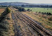 |
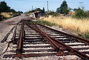
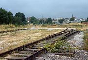
A scene of dereliction at Toddington on 14 October 1979, and a vast difference to the busy scene today. This is the far end of the yard at Toddington station, at what would later become the headquarters of the Gloucestershire Warwickshire Railway. The top of a signal post gives a good view of the line heading off towards Hailes. The weed grown track is only a few weeks away from being lifted. The overgrown area near the field boundary on the right is now the course of the North Gloucestershire Narrow Gauge Railway. |
|
 |
Toddington station slumbers amid the weeds on 7 October 1978. This was several years before the Gloucestershire Warwickshire Railway took over, and nothing much happened for another year, so that when I returned the following autumn, the view from the top of the up home signal looked very similar. |
|
 |
Toddington station in limbo on 14 October 1979, three years after the line was closed and just a few weeks before the track was lifted. Of course this location looks very different now, as it is the thriving hub of the Gloucestershire Warwickshire Railway, who took over the site in 1981. Happily all the GWR brick built buildings seen here survived. The station had closed in 1960 and the once extensive sidings lifted, leaving just the one visible on the left for use by engineers trains. |
|
 |
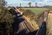
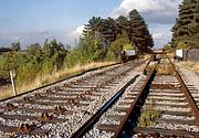
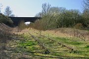
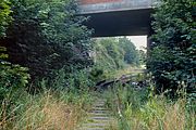
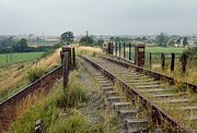
Looking towards Stanway Viaduct from just north of Toddington station on 14 October 1979. Tracklifting is about to take place, and indeed the rails on the up line have already been removed prior to lifting out the sleepers. The Gloucestershire Warwickshire Railway has since relaid this section of the route. |
|
 |
The moribund Cheltenham to Stratford-upon-Avon line near Stanton, pictured on 14 October 1979. This view looking north from the A46 road bridge shows that the rails have been removed from the up line prior to recovery. Happily this section of line is now operational again as part of the Gloucestershire Warwickshire Railway. |
|
 |
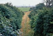
The disused Cheltenham to Stratford-upon-Avon railway, pictured on 22 October 1978, two years after closure, and a year before the track was lifted. This is the view near Laverton, looking north, with the Laverton to Wormington road underbridge in the centre of the picture. The spire of Childswickham church can just be seen in the distance. |
|
 |
Broadway Goods Shed pictured on 22 October 1978. Unfortunately this is a rather poor quality picture, taken in gloomy conditions, but it is the only picture I have of the goods shed from the north end, showing the remains of the cattle dock. I returned the following year, and photographed the shed in much better light, but by then track lifting was already underway. |
|
 |
Broadway Goods Shed pictured on 14 October 1979. The Cheltenham to Stratford-upon-Avon line closed in 1976, and I just managed to arrive in time to photograph the track before lifting, although not before the rails on the up line had been removed from their fastenings, as seen here in the foreground. The GWR built shed survives, although the corrugated iron extension on the right has since been removed. |
|
 |
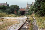
The site of Broadway station, on the disused Cheltenham to Stratford-upon-Avon line, pictured looking towards Willersey on 14 October 1979. The platforms were situated just beyond the road underbridge, underneath the Scots Pine trees (an obvious giveaway for a GWR station site!). The goods yard was situated behind me to the right. The line closed in 1976 and tracklifting was in progress when I visited three years later, as can be seen by the lifted rails on the up line. Note the piles of fishplates and track keys on the down line. |
|
 |
The bridge over the disused Cheltenham to Stratford-upon-Avon line at Weston Subedge, pictured on 14 October 1979. The weed choked track and line of telegraph poles make a historic picture, although the sewage works is slightly less photogenic! And yes, that is the shadow of my parked car (a Toyota Corolla in those days) in the foreground! An industrial unit now occupies the field on the right. |
|
 |
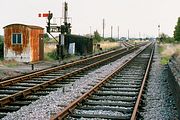
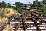
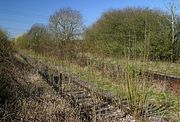
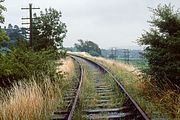
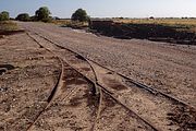
Honeybourne West Loop Junction, on the disused Cheltenham to Stratford-upon-Avon line, pictured on 14 October 1979. This view is looking towards Weston-sub-Edge, and shows the 1960 built signal box, with sidings just visible behind. This route closed in 1976, and tracklifting was in progress a little further south, but hadn't quite reached this far yet, so for the moment nature is getting the upper hand! |
|
 |
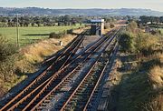
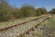
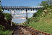
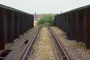
Honeybourne West Loop Junction, looking towards Stratford-upon-Avon on 14 October 1979. The actual junction is just in front of the bridge in the background, which carries the Worcester to Oxford 'Cotswold Line' over the route. After over three years out of use, all trackwork and structures are still in place. Surprisingly all the semaphore signals are also still in situ. At least some of these collectors items would probably go missing nowadays! Incidentally, the missing distant arm on the right hand bracket had already been removed (presumably officially!) by the mid 1970s. |
|
 |
Honeybourne West Loop Junction, pictured on 23 January 1982. The track had been partially lifted a couple of years earlier, but the junction itself (near the bridge in the background) is still intact. Lifted track panels can just be seen underneath the bridge that carries the Cotswold Line over the former route to Stratford-upon-Avon. The removal of the rest of this track was very leisurely. By 1983 the point in the foreground still survived, with track panels and loose sleepers littering the trackbed right up to the bridge. However, by 1984 all had gone. |
|
 |
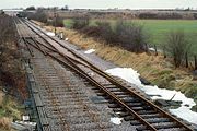
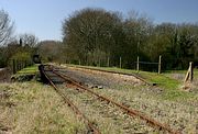
Honeybourne West Loop Junction, viewed from the top of down line signal on 14 October 1979. The Cotswold Line crosses the Stratford-upon-Avon route in the background, and a few wagons can just be seen on the old Honeybourne tip, on the left. |
|
 |
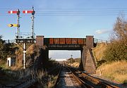
Honeybourne West Loop Junction, pictured on 14 October 1979. This is the view looking back towards Honeybourne West Loop Signal Box, which just be seen underneath the bridge in the background. The line in the immediate foreground is the curve linking the Cheltenham to Stratford-upon-Avon route with the Oxford to Worcester 'Cotswold Line'. |
|
 |
The last remaining section of track at Long Marston station, pictured on 14 August 1983. With the majority of the trackwork recently lifted, just the connection into the army depot remains, and that too would soon be gone. This location is now in the middle of an industrial estate, with my vantage point probably inside one of the 'big sheds'! |
|
 |
The southern end of Long Marston station pictured on 31 August 1981. This was just before a new direct connection into the army base came into use, so the left track was at least theoretically still in use at this time. Note that although returning trains would need to use the left hand track towards the bridge in the background, only the line curving off into the depot still retains a working semaphore signal. There's not a lot of paint left on the standard GWR lamp hut! |
|
 |
Long Marston station viewed from the top of the down home signal on 31 August 1981. The station, which can be seen beyond the crossing gates closed in 1966, but the line from Honeybourne was retained for the as required movements into the nearby army base (behind the bushes on the left). I'm not too sure whether this picture truly deserves to be included in a 'Disused Railways' section, as the slight sheen on the down line gives a clue that the line has been used fairly recently. Incoming trains had to reverse into the yard, and consequently a new direct connection was added near the bridge in the background. This came into use 16 November 1981. However, as can be seen by the invading brambles on the track, the up line has been out of use for years. |
|
 |
During the spate of railway closures in the 1960s, it was usual for the track to be recovered within a couple of years, leaving just a ribbon of ballast to become progressively more overgrown through the succeeding decades. However, for some reason the line from Blodwell to Nantmawr (near Oswestry) did not get a visit from the scarp man. Instead the track became engulfed with lush Welsh vegetation. Such was the extent of the growth, that when I visited the line on 2 August 1987, some sections were completely impenetrable, with full grown trees growing through the ballast between the sleepers! This is one of the more open sections near Nantmawr. In recent years the line has been cleared and reopened as the Tanat Valley Light Railway. |
|
 |
Rosebay Willowherb and brambles take over the disused sidings near Walton Well Road, Oxford, on 21 August 1982. These were the sidings to the north of the former Oxford loco depot, and by 1982 had been out of use for some considerable time. The main line to Banbury can be seen behind the gates, with Walton Well Road bridge in the background. These sidings were lifted many years ago, and now the site is underneath Roger Dudman Way, the approach road to the hideous student tenement blocks that have now blighted the west of Oxford. |
|
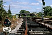 |
The OX160 shunting signal is lit, but nothing has been this way for a very long time. This is the view from the sidings just to the north of Oxford station, looking towards the Banbury main line, with Walton Well Road bridge in the background. The steel span on the left is over the current, former GWR line, whilst the brick span on the right is over the former LMS route. The picture was taken on 21 August 1982. The line in the foreground was lifted in the late 1980s. |
|
 |
The section of the former Oxford to Cambridge line between Claydon Junction and Bletchley last saw a train in 1993. Since then nature has been allowed to take over, with some sections getting very overgrown. One of the clearer sections in shown here on 27 March 2012. This is looking west, back towards Claydon Junction, from a point just south of the village of Steeple Claydon. The board warned drivers of the approach to Steeple Claydon Level Crossing |
|
 |
Looking towards Steeple Claydon level crossing, on the disused (for the moment!) Oxford to Bletchley line on 27 March 2012. This is one of the more open sections, with brambles and other bushes encroaching on the track in many places. |
|
 |
The remains of Steeple Claydon Level Crossing pictured on 27 March 2012. Despite appearances, the rails are still present on the other side of the fence, but young ash trees are finding the ballast no hindrance to growth. The last train crossed this road nineteen years previously. |
|
 |
Claydon Station was situated between the villages of Steeple Claydon and Middle Claydon, and was opened by the Buckinghamshire Railway in 1850. It closed, along with neighbouring stations on the Oxford to Bletchley line, in 1968, although the line remained open for freight until 1993. The remains of the platform are seen here on 27 March 2012. |
|
 |
The rusting track of the closed Oxford to Bletchley line is pictured here on 27 March 2012. This view is looking west from near the site of Verney Junction, near the point where the line to Buckingham diverged off to the north. |
|
 |
Verney Junction reverts to nature, with sizeable ash trees growing between the rails. This view, taken on 27 March 2012, shows that both platforms are intact, although apart from the station master's house, no buildings remain. Will trains ever pass this way again? There are plans to reopen the line, although it is doubtful whether such a remote station will see further use. |
|
 |
The disused Oxford to Bletchley line at Winslow, pictured on the unseasonably warm 27 March 2012. This is one of the more vegetation free sections of the Claydon to Swanbourne stretch, which last saw a train in 1993. From Swanbourne onwards the track has been lifted. This is looking towards Swanbourne. |
|
 |
Despite having closed as long ago as 1968, Swanbourne station looks remarkably tidy in this view, taken on 27 March 2012, thanks presumably to the residents of the station house. The platforms now boast a lush soft springy grass surface, but no passengers loiter and no trains run! |
|
 |
The last few yards of extant track at Swanbourne, on the former Oxford to Bletchley line, pictured on 27 March 2012. Swanbourne Station is just behind me, while just on the other side of the bridge, the track towards Bletchley has been lifted. |
|
 |
Despite appearances, there really still is a line of rails passing underneath this bridge! Just to the east of Swanbourne station the Mursley to Little Horwood road crosses the Oxford to Bletchley line via this weather beaten brick bridge. Pictured on 27 March 2012, this is looking north east, towards Newton Longville. |
|
 |
The end of the line at Swanbourne on 27 March 2012. Looking towards Newton Longville and Bletchley, this view shows the last few yards of remaining track on the section of the disused line from Claydon Junction. If local plans come to fruition, this could once again become part of a cross country passenger route. |
|
 |
The end of the line at Swanbourne on 27 March 2012, looking back towards Swanbourne station (out of sight underneath the bridge). From here onwards the track was lifted, but reinstated between Bletchley and Newton Longville in 2006. |
|
 |
With the parapets of the Hunningham to Long Itchington road underbridge in the foreground, this is the view looking north east along the closed in all but name Rugby to Southam Cement Works line on 2 June 1984. The line was opened by the London & North Western Railway in 1851, linking the towns of Rugby and Leamington Spa. |
|
 |
A super abundance of hawthorn blossom at Marton Junction on 2 June 1984. This view looking east from the impressively high Honingham Hill Road Bridge shows the Junction where the line to Southam Cement Works diverged from the Rugby line. The line can be seen heading for several miles in an almost dead straight line towards Rugby. Although not actually officially closed when this picture was taken, all traffic had effectively stopped and the rails were completely rusty. Bizarrely the weedkilling train traversed the entire route in 1985. |
|
 |
Marton Junction pictured on 2 June 1984 with the Honingham Hill Road Bridge spanning the actual junction. The line to Southam Cement Works can be seen diverging to the right, while straight on leads to Rugby. Incoming trains would have to run round using the loop in the foreground. Although not officially closed at this time, the state of the track indicated it was a long time since a train had passed this way. |
|
 |
Snowford Farm watches over the rusting remains of the Southam Cement Works Branch on 2 June 1984. This view is just a short distance from Marton Junction, where the branch curves through almost 90 degrees away from the line from Rugby. This was once part of the LNWR's through route from Warwick to Bletchley via Daventry. Cement traffic had virtually finished by this time and apart from the extraordinary time and money wasting visit of the weedkilling train the following year, saw no further traffic until the line was lifted in the 1990s. |
|
 |
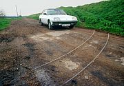
When the Midland & South Western Junction Railway closed as a through route in 1961, a short section survived at Swindon, both north and south of the junction with the Great Western Mainline at Rushey Platt. The southern section to Swindon Town station was lately used as a roadstone base for the construction of the nearby M4 motorway in the early 1970s. The end of the line was just short of the bridge over Evelyn Street and is shown here on 22 August 1978. No buffer stop of any kind was provided! The track was lifted shortly after this picture was taken, and although the bridge whose parapets can be seen still survives, it would be impossible to take this picture today, as you would be inside somebody's front room in one of the newly built house on the site! |
|
 |
The remains of Swindon Town station pictured on 22 August 1978 in a brief burst of weak sunshine on an otherwise dull day. It had last seen trains several years before when numerous stone trains worked from the Westbury area to help with the construction of the M4 motorway. This whole site has now completely disappeared under a new industrial estate. However, the former MSWJR offices (the brick built building seen through the gap in the trees) still survives. |
|
 |
The remains of Swindon Town station looking west on 22 August 1978, with some of the platform coping stones allegedly removed as they were fouling the wagons used on the stone trains in the early 1970s. Vegetation is taking over, but the scene would shortly be transformed, with the track being lifted and an industrial estate built on the site. The bridge does still survive as it marks the start of a cycleway which follows the course of the line around the southern edge of Swindon. |
|
 |
The approach to Swindon Town station from the west, pictured on 22 August 1978. The track on this section of the old MSWJR route was in its last few weeks of existence, as track lifting was only a few hundred yards away. This bridge, which carried the A4361 Swindon to Wroughton road over the line still survives, but the trackbed is now a cycle track. |
|
 |
The old Midland & South Western Junction Railway line just west of Swindon Town station, pictured on 22 August 1978, shortly before the track was lifted. As can be seen from the weed choked track and lineside growth, nothing had been this way for a long time. |
|
 |
The disused Midland & South Western Junction Railway, just to the south of Swindon, pictured on a very gloomy 22 August 1978. When this picture was taken, this marked the limit of the southwards expansion of Swindon, with only the nearby M4 motorway spoiling the view of the countryside to the south. |
|
 |
The old Midland & South Western Junction Railway curves round to the south of Swindon on a low embankment. This is the view looking east near the Mill Lane underbridge, taken on 22 August 1978. Quite why I took these pictures on such a dreary day I cannot now explain, but as the track was being lifted just a short distance to the west, a repeat visit was out of the question. |
|
 |
The former Midland & South Western Junction line is pictured on a gloomy 22 August 1978 just to the south of Swindon where the course of the line crosses the Wilts & Berks Canal on a skew bridge. The track was lifted just weeks after this picture was taken. Surprisingly given the proximity to the ever expanding town of Swindon, this view has only changed a little. More houses have now been built in the field on the right, but the land to the left is still rural. The course of the line is now a cycle track. |
|
 |
Track lifting at Rushey Platt, on the former Midland & South Western Junction Railway, on a very gloomy 22 August 1978. This must have been the very start of lifting operations, as the rest of the section between Swindon Old Town and Moredon was still intact. This short section of the old M&SWJR route had survived to serve a temporary stone terminal at Swindon Town, and Moredon Power Station, leaving several miles of the old track to the south and west of Swindon. Although not particularly apparent here, this section is on an embankment. This now forms part of National Cycle Network Route 45. |
|
 |
The former Midland & South Western Junction line crossed the Great Western Mainline at Rushey Platt via this girder bridge. It is pictured here looking north on 22 August 1978, shortly before it was removed. Although presumably the steelwork was sound, there were numerous missing planks, through which HSTs could be seen speeding by! |
|
 |
Nature is reclaiming the old Midland & South Western Junction Railway route at Moredon on 22 August 1978. This is the view looking south from the farm occupation bridge situated between the site of Moredon Power Station, and where the line crosses the Swindon to Gloucester line. |
|
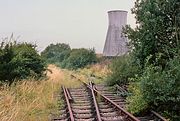 |
In addition to the short section of line leading south from Swindon to Swindon Town, another length of the former MSWJR was retained after the through route closed in 1961, this time northwards to serve Moredon Power Station. The power station was opened in 1929 and continued taking in coal deliveries by rail for the next forty years. It finally closed in 1973 and was demolished in 1979 to make way for the inevitable housing estate. The trackwork is getting rapidly overgrown in this 22 August 1978 view, with Moredon's solitary cooling tower in the background. Within a few months the scene would be changed totally, with the track lifted and the power station gone. |
|
 |
The long disused former Midland & South Western Junction Railway route at Moredon, pictured on 22 August 1978. This is the view looking south towards the bridge carrying the Moredon to Common Plat road over the line. Just off to the left of the picture, a local landmark at this time was the cooling tower of the disused Moredon Power Station. |
|
 |
Looking north along the last few yards of the extant former Midland & South Western Junction Railway at Moredon, near Swindon, on 22 August 1978. This section of line was retained for the benefit of the nearby Moredon Power Station. The track was lifted shortly after this picture was taken, but surprisingly this farm occupation bridge still survives. However, instead it of it being in a rural location, as when photographed here, it is now next to the busy Thamesdown Drive, which is effectively a ring road for the western expansion of Swindon. |
|
 |
Looking south towards the farm occupation bridge at Moredon on 22 August 1978. This was the heavily overgrown extremity of the former Midland & South Western Junction Railway, retained after the closure of the rest of the line for use by coal trains going to Moredon Power Station. The line just ended, with no buffer stop of any kind, just a few yards behind where I am standing. |
|
 |
During the 1970s a short length of the former Midland & South Western Junction Railway was retained from the Great Western Mainline at Swindon as far north as Moredon Power Station. The line extended for approximately ½ mile beyond the power station in what was presumably intended as a very long headshunt. I assume no trains ever ventured up this far, and consequently there was no need to provide a buffer stop! The very end of the line is just about visible in the undergrowth in this 22 August 1978 view. The track was lifted a few months later. Note the very characteristic feature of many landscape pictures taken in the 1970s - the row of dead elm trees on the horizon, recently killed by Dutch elm disease. |
|
 |
The remains of Parkend station, pictured on 18 August 1978. This is now the northern terminus of the Dean Forest Railway, but is shown here in an abandoned state, over a decade after the passage of the last freight train. It is surprising that the platforms survived, as it closed to passengers as long ago as 1929! Just visible by the level crossing gates in the background is my first car - a 1971 Toyota Corolla. |
|
 |
Looking south from Parkend station on 18 August 1978. All is quiet, with a solitary sheep wandering across the tracks. The line closed to freight in March 1976, and became progressively more overgrown, until eventually taken over by the Dean Forest Railway. Passengers services, which had ceased in 1929, resumed in 2005. |
|
 |
Although it closed as a through route in 1964, the southern end of the Wye Valley line remained open for freight until 1990. Initially stone trains from Tidenham Quarry kept the line busy, but these ceased in 1981 and the line was cut back to Dayhouse Quarry. This traffic finally came to and end in March 1990, and the junction with the main line (appropriately named Wye Valley Junction) was removed. The rusting line is pictured on 17 March 2007, just at the point were it curves away from the main line, which is already at a much lower level, looking towards Tidenham. |
|
 |
It has been several years since the last train passed this way, as vegetation begins to encroach on the track at Tidenham on 18 August 1984. The Great Western Railway's Wye Valley route closed in 1964 with the exception of the southernmost section to Tidenham Quarry. Hidden in the bushes in the background is the bridge that carries the minor road from Tidenham to Lancaut over the line, and just a few yards beyond that is the entrance to Tidenham Tunnel. |
|
 |
The southern portal of Tidenham Tunnel pictured on 18 August 1984, just a few years after the line closed, and long before the surrounding vegetation virtually completely obscured the view. Also, since this picture was taken, the inevitable fence has been erected to prevent unauthorized access. |
|
 |
Dunford Bridge station, pictured in the rain on 19 August 1981, a month after the last train had traversed the line. The Woodhead line had been electrified in 1953 using the 1,500V DC overhead system. However, after the passenger services were withdrawn in 1970, freight traffic gradually dwindled, and when expensive refurbishment was required on the line's unique Class 76 locomotives, the decision was taken to close the line instead. I never visited the line when it was open, but at least this is a record shot before the track was lifted. Note the ultra short platforms of Dunford Bride station, which only served a few scattered houses. The Woodhead Tunnel is just behind where I am standing, and on the left is the 2 foot gauge railway used by the National Grid to access one bore of the adjacent original tunnel. |
|
 |
The 2ft gauge Alford Valley Railway closed in 2017, due to the condition of the track. It is hoped to reopen the line, but as can be seen from this 31 August 2018 picture, the line is currently disused. This is the extremely sharp curve taking the line from running parallel to the delightfully named Lang Stracht road, to run alongside Alford Golf Course. Note the check rail. |
|
 |
The currently disused Alford Valley Railway, pictured on 31 August 2018. This is the view looking north, next to Alford Golf Course. The rather heavy looking rails were salvaged from the New Pitsligo peat moss railway, which closed in 1978. |
|
 |
A mystery railway relic in the Fens. Rails cross Lark Bank, the rough track that runs alongside the River Lark, a few miles to the east of Ely. Only this section was intact at the time (16 April 1988), presumably as it had been too difficult to remove. I'm unsure of the gauge, but my Vauxhall Cavalier is included for scale! The line went from the fields off to the left of the picture, to the river bank on the right. The course of the track though the grass can clearly be seen. These rails have since been removed. Although the 1925 Ordnance Survey 25 inch map shows tramways extending across the fields from nearby Laurence Farm and Lark Grange, nothing is shown crossing Lark Bank. The tramways were presumably potato railways, as were once common in Lincolnshire. This was the site of White Top Mill, so that may also have something to do with it. Any information would be gratefully received. |
|
 |
Bank Top on the Swinefleet Peat Railway, pictured on 1 September 2002, over two years after the line ceased operations. The lightly laid 3 ft gauge track can be seen paralleling the access road to the moors. Lines diverged at right angles to access the moss cutting area to the right of this picture. |
|
 |
Track reclamation underway at Bank Top on the Swinefleet Peat Railway on 1 September 2002. The 3 ft gauge line had closed two years earlier, and although the trackwork was still largely intact when I visited, a start has obviously be made to recover the materials. Bank Top was the main depot, midway between the peat works (which had good road access) and the peat workings out on the moors. The remains of the refueling depot can be seen on the left in this view, amongst which Motor Rail 0-4-0 diesel 40s302 was dumped. The still intact 'main line' is virtually hidden in the gravel, but runs along the right hand side of the roadway here, with the junction for the line leading across Goole Moors by the gap in the machinery. |
|
 |
The junction at Bank Top on the Swinefleet Peat Railway, where the line to the peat workings on Goole Moor diverged from the 'main line'. This picture was taken on 1 September 2002, shortly after the whole system had closed. The line follows the edge of the gravel road before turning through ninety degrees in the distance, and then heading towards the peat works. The line carrying straight on in the foreground passed the refueling depot and headed out to more peat diggings alongside the Backwater Dyke. |
|
 |
How about this for some seriously dodgy tracklaying! It is not surprising that the Swinefleet Peat Railway suffered from numerous derailments when the switchback nature of the track is taken into account. This picture, taken on 1 September 2002, shows the line heading across Goole Moors from the main depot at Bank Top. Peat has been extracted from either side of the line, leaving it on an embankment. Nature is already reclaiming the area in the background, and the whole area is now a nature reserve, with all traces of the 3 ft gauge railway removed. |
|
 |
The rusting rails of the disused 3 ft gauge Swinefleet Peat Railway stretch out across Goole Moors on 1 September 2002, with the gravel ballast contrasting sharply with the black peat diggings on either side of the line. The peat extraction has left the railway on a substantial embankment at this point. Eggborough Power Station can just be seen on the horizon at the far end of the line, while the chimney of Drax Power Station peers out from behind the bushes on the extreme right of the picture. |
|
 |
The southern end of the 3 ft gauge Swinefleet Peat Railway, pictured on 1 September 2002. The line coming in from the right leads to Bank Top depot and ultimately the peat works. After traveling for some distance alongside the gravel road, it traverses this ninety degree bend to head off alongside the Backwater Dyke to an area of peat diggings known locally as the Shoulder of Mutton. The entire system closed in July 2000 and all trackwork has now been lifted. |